From 2008 to 2010, ecosystems assessments were conducted in Tinoc, Ifugao, using CBD indicators on land use and land use change, land tenure, indigenous languages, traditional occupations and people’s wellbeing (See case study “Summary data on the global headline indicators adopted by the CBD in relation to Target 18”).
From 2008 to 2010, ecosystems assessments were conducted in Tinoc, Ifugao, using CBD indicators on land use and land use change, land tenure, indigenous languages, traditional occupations and people’s wellbeing (See case study “Summary data on the global headline indicators adopted by the CBD in relation to Target 18”). Community research was carried out in 5 of the 12 barangays or administrative villages of Tinoc: Ahin, Wangwang, Tulludan, Tukucan, and Binablayan. This assessment employed cultural and GIS mapping, workshops, surveys and interviews, as well as secondary data and government rural health clinic records on frequency of childhood illnesses.
When Tebtebba started the work, people were very cautious to speak about their traditional knowledge, owing to long experience of discrimination. Also, research was seen as the work of academics and professionals, and information seldom ended up in the hands of the community. Demystifying research encouraged participation. It was important for people to realise that anyone can be involved in research and the creation of knowledge, and that this is part of everyday life, and can be transmitted through storytelling, songs, rituals and art, and in other ways.
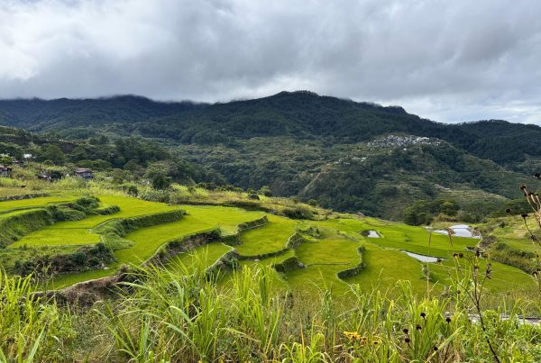
The research project showed that traditional territorial management was vibrant up to the mid 1990s, but with the adoption of chemical-based commercial vegetable production, communities veered away significantly from traditional practices. A new category of land-use and associated technologies appeared in which the land is privately owned and managed outside the customary community rules. This has caused forest degradation and river siltation, drying up of natural springs, exploitation of farmers by the market system, and food insecurity, among other effects1
Traditional monitoring systems still exist, such as the giti, for monitoring irrigation systems and changes in seasons and weather. For example the maturing of the pullet plant signals the time to start land preparation in the irrigated riceland, and the arrival of kiling birds indicates that storms have passed and that it is time to start planting rice. The accuracy of these traditional indicators in the context of climate change needs further study.
The process of participatory action research enabled the Kalanguya people to :
- Revitalise their indigenous knowledge systems and practices for territorial management;
- Understand negative impacts arising from their adoption of chemical-based, commercial vegetable farming;
- Adopt a Community Land Use Plan addressing the problems that were identified.
After more than a year of participatory action research the Kalanguya fully appreciated the wisdom and science of their indigenous knowledge, which embodies sustainable resource use and equitable sharing of resources. The study showed that indigenous territorial management among the Kalanguya is based on land use patterns that manifest man-land-nature and spirit relationships, based on biodiversity, culture and spiritual values.
Communities used the emerging data to draw up action plans which varied from village to village. In the Wangwang community, where data showed that the forest is largely intact, the community’s aim is to upgrade their traditional knowledge and to strengthen customary sustainable use and customary laws. On the other hand in Tukucan the data showed a significant reduction in the coverage of the bel-ew watershed protection forest, from 1108.73 hectares in 1970 to 717.65 hectares in 2009. Much of the forest had been cleared for commercial vegetable farming and the range of foods eaten by the community was less diverse compared to those previously collected from the forests and swidden farms. Here, the aim of the community is to reclaim the watershed area from degradation and privatisation, assist in forest regrowth and shift from chemical-input farming to ecological or sustainable farming. One member of Tukucan concluded:
“For as long as one is willing to work the land, no one will be hungry. But hunger will occur if we deprive man of the land that is the basic means of production”2
A land summit was held to unite the communities around the findings of the community assessment. Policies were developed to protect watershed areas and river systems, and to monitor crop yields. Through this process it was realised that although people spoke the Kalanguya language in family conversations, terms relating to customary laws were no longer widely known.
A unity pact or covenant to arrest environmental degradation and promote peoples’ wellbeing was agreed among community leaders. To realise this covenant, a comprehensive land use plan was formulated with the following goals:
- Enhanced ecosystems for increased food sovereignty and community resilience;
- Strengthened customary governance for the promotion of traditional values, customary sustainable use and equitable sharing of resources; and
- Strengthened people’s advocacy for appropriate development programmes and improved social services
Activities related to awareness-raising, capacity-building, project development, community resource mobilisation, policy advocacy and networking were agreed upon, and indicators were adopted for monitoring progress.
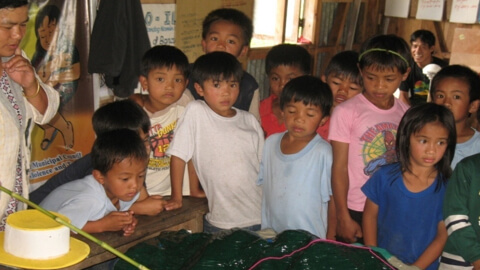
Image caption: Workshop among commercial vegetable growers, Tukucan, Tinoc, September 2009
Author
- Florence Daguitan, Tebtebba
Ecosystems
Type
Year
Date
- This case study forms part of LBO-1, originally released in 2016.